
Follow LVIS
External Links
- 61A: Geodesy and Geophysics Laboratory
- Operation IceBridge
- ABoVE
- NSIDC
- GEDI
- GRACE
- University of Maryland
Recent News
LVIS featured on #ScienceInSeconds
28 Jul 2021
Dr. Michelle Hofton was interviewed for NASA Associate Administrator Dr. Thomas Zurbuchen's Twitter update during the 2021 GEDI Calibration/Validation campaign!
Greenland data available at NSIDC
14 Jun 2018
LVIS Level 1B and 2 data products from Operation IceBridge Greenland 2017 are now available at NSIDC. Links are now available here!
ABoVE data available at NSIDC
9 May 2018
LVIS Level 1B and 2 data products from ABoVE 2017 are now available at NSIDC, and the IceBridge 2017 data products have been sent out. Take a look here!
ABoVE data sent to NSIDC
8 Mar 2018
LVIS data from ABoVE 2017 has been sent to NSIDC. As soon as the data is available, links will be posted here!
LVIS Gabon 2023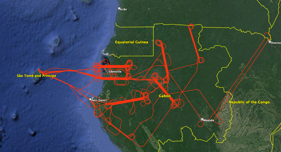
In May 2023, NASA's LVIS Facility was used to collect data over Gabon, Africa and neighboring countries. Two LVIS lidars and one camera were operated on the NASA LaRC Gulfstream-III aircraft. Science targets included sections of GEDI reference ground tracks, areas where complementary ground and airborne-based data collections exist, and LVIS data collection sites flown previously as part of the 2016 AfriSAR campaign. Sections of LVIS data collection areas were also flown by the DLR FSAR sensor during the same time period. Flight trajectories and preliminary coverage maps are available on this page. Use the python code posted here to view the data products from this mission. |
LVIS Mission Information
|
ResourcesAirports
| ||||||||||||||||||||||||||||||||
Data Products
| LVIS Data Products | Format | Download Location |
| Flight Trajectories | KMZ | This page |
| LVIS L1A Camera Imagery | JPG* | NSIDC1, NASA EarthData |
| LVIS Classic L1B Geolocated Waveforms | HDF, LDS 2.0.3 | NSIDC1, NASA EarthData |
| LVIS Classic L2 Elevation and Height Products | ASCII TXT, LDS 2.0.3 | NSIDC1, NASA EarthData |
1 At NSIDC, search for date ranges 01 May 2023 through 31 May 2023
| View | MJD | Date | Region / Remarks | GPS Flight Trajectory | Preliminary LVIS Coverage* (Key) | L2 Gridded KMZs† | Photo KMZs† | ||
|---|---|---|---|---|---|---|---|---|---|
| Classic | Facility | ||||||||
| 60079 | 15 May 2023 | Sensor calibration flight, Delmarva Peninsula | [kmz] | [kmz] | |||||
| 60083 | 19 May 2023 | Science Flight 01 | [kmz] |
[ZG] [RH95] |
[kmz] | ||||
| 60084 | 20 May 2023 | Science Flight 02 | [kmz] |
[ZG] [RH95] |
[kmz] | ||||
| 60086 | 22 May 2023 | Science Flight 03 | [kmz] |
[ZG] [RH95] |
[kmz] | ||||
| 60087 | 23 May 2023 | Science Flight 04 | [kmz] |
[ZG] [RH95] |
[kmz] | ||||
| 60088 | 24 May 2023 | Science Flight 05 | [kmz] |
[ZG] [RH95] |
[kmz] | ||||
| 60089 | 25 May 2023 | Science Flight 06 | [kmz] |
[ZG] [RH95] |
[kmz] | ||||
| 60091 | 27 May 2023 | Science Flight 07 | [kmz] |
[ZG] [RH95] |
[kmz] | ||||
| 60093 | 29 May 2023 | Science Flight 08 | [kmz] |
[ZG] [RH95] |
[kmz] | ||||
| 60094 | 30 May 2023 | Science Flight 09 | [kmz] |
[ZG] [RH95] |
[kmz] | ||||
| 60095 | 31 May 2023 | Science Flight 10 | [kmz] |
[ZG] [RH95] |
[kmz] | ||||
| May 2023 | All Flights | [kmz] | |||||||
*Preliminary LVIS Coverage locations are generated shortly after a flight and based on quicklook product information and are intended for general guidance only.
Key: Red=0%, Pink=1-10%, Orange=10-20%, Yellow=20-50%, Green=50-100%
†Warning: Gridded and Photo KMZ files are large and may take some time to load in Google Earth
