
Follow LVIS
External Links
- 61A: Geodesy and Geophysics Laboratory
- Operation IceBridge
- ABoVE
- NSIDC
- GEDI
- GRACE
- University of Maryland
Recent News
LVIS featured on #ScienceInSeconds
28 Jul 2021
Dr. Michelle Hofton was interviewed for NASA Associate Administrator Dr. Thomas Zurbuchen's Twitter update during the 2021 GEDI Calibration/Validation campaign!
Greenland data available at NSIDC
14 Jun 2018
LVIS Level 1B and 2 data products from Operation IceBridge Greenland 2017 are now available at NSIDC. Links are now available here!
ABoVE data available at NSIDC
9 May 2018
LVIS Level 1B and 2 data products from ABoVE 2017 are now available at NSIDC, and the IceBridge 2017 data products have been sent out. Take a look here!
ABoVE data sent to NSIDC
8 Mar 2018
LVIS data from ABoVE 2017 has been sent to NSIDC. As soon as the data is available, links will be posted here!
LVIS Data Products Overview
LVIS data products rely on information contained in the geolocated laser return waveform (the LVIS Level 1B product). Locations of several modes and reflecting points are extracted using signal processing methods, then geolocated using the infomation in the L1B file, and and output in the Level 2 product files. These include elevations (with assoicated latitudes and longitudes) for the center of the lowest and highest modes in the waveform as well as the highest detected return (e.g., canopy top). We also integrate the energy contained within the waveform and extract out the locations where, for example, 25, 50, and 75% of the total return energy occurs. These are also geolocated relative to a global reference frame then differenced to the zg product to derive a relative height (e.g, RH25). An overview of some of the products contained in the Level1b and Level2 products is shown below.
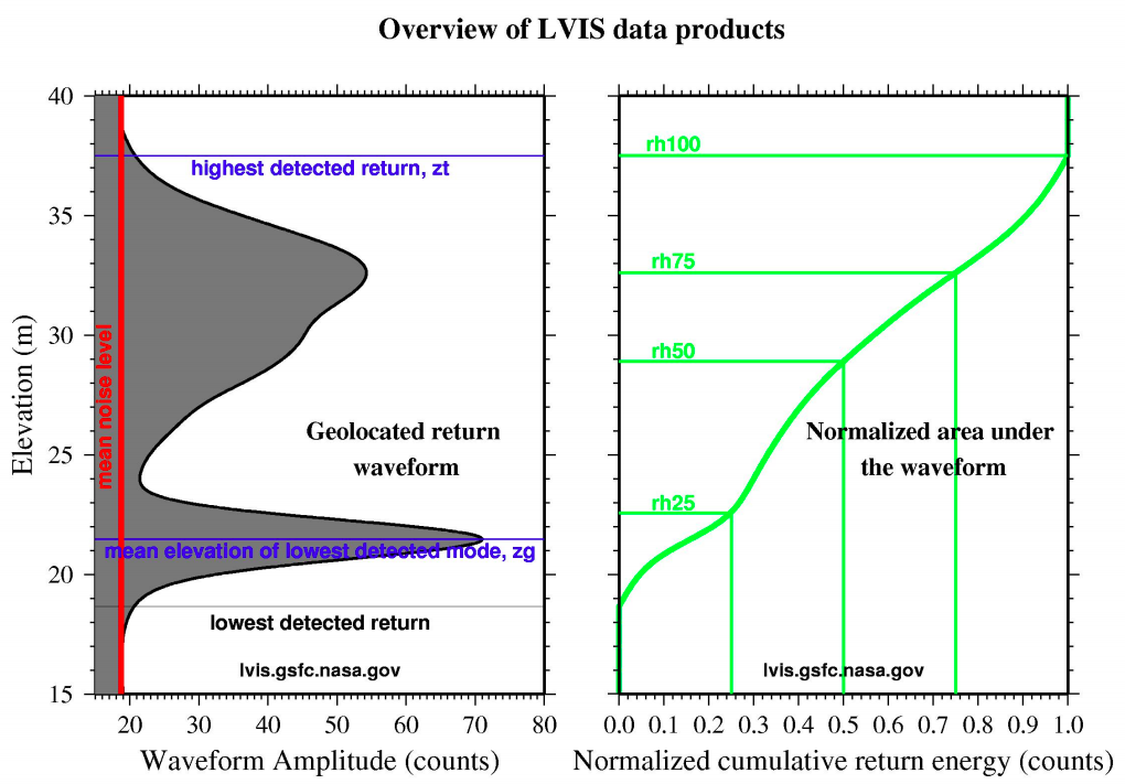
Although we provide standard products for each footprint, it is left to the end user to pick which product may be more appropriate for their use. For example, in simple, non-complex terrain such as the smooth interior of an ice sheet, the "low" and "high" surfaces will be identical since the laser return waveform will only contain one ~gaussian mode. However, over more complex terrain, for example, crevassed or rocky surfaces where multiple reflecting modes occur within the laser footprint, these two surfaces will occur at different elevations. Some Level 2 data formats also contain the elevation corresponding to the centroid of the return signal, however the user must be cognizant of the impact of the shape of the returning laser pulse if using this elevation.
LVIS has been collecting data since 1997 for various objectives, and several evolutions of the data product structure have occurred. With the start of the LVIS Facility in 2017 we have standardized the data format and begun reissuing data.
| Version | Description | Script |
|---|---|---|
| LDS 1.02 | Legacy LVIS data format, pre-2009 | read_legacy_lvis.py |
| LDS 1.03 | Legacy LVIS data format, pre-2009 | read_legacy_lvis.py |
| LDS 1.04 | Legacy LVIS data format, 2009-2015 Operation IceBridge | read_legacy_lvis.py |
| LDS 2.0.1 | 2016 AfriSAR | py_waveplot.py |
| LDS 2.0.2 | 2017 ABoVE and Operation IceBridge | py_waveplot.py |
| LDS 2.0.3 | 2019-2024 (land surfaces) | py_waveplot.py |
| LDS 2.0.4 | 2022, 2024 (ice surfaces) | py_waveplot.py |
| LDS 2.0.5 | 2023 (land surfaces) | py_waveplot.py |
Camera Imagery
For flights with associated camera imagery, we have modified the Exif tag structure to include time, position and pointing infomation.
These images are available both in a reduced version within a Google Earth KMZ file and as full resolution JPEGs.
