
Follow LVIS
External Links
- 61A: Geodesy and Geophysics Laboratory
- Operation IceBridge
- ABoVE
- NSIDC
- GEDI
- GRACE
- University of Maryland
Recent News
LVIS featured on #ScienceInSeconds
28 Jul 2021
Dr. Michelle Hofton was interviewed for NASA Associate Administrator Dr. Thomas Zurbuchen's Twitter update during the 2021 GEDI Calibration/Validation campaign!
Greenland data available at NSIDC
14 Jun 2018
LVIS Level 1B and 2 data products from Operation IceBridge Greenland 2017 are now available at NSIDC. Links are now available here!
ABoVE data available at NSIDC
9 May 2018
LVIS Level 1B and 2 data products from ABoVE 2017 are now available at NSIDC, and the IceBridge 2017 data products have been sent out. Take a look here!
ABoVE data sent to NSIDC
8 Mar 2018
LVIS data from ABoVE 2017 has been sent to NSIDC. As soon as the data is available, links will be posted here!
ABoVE 2017
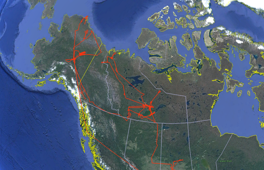
In June-July 2017, the NASA LVIS Facility was deployed to sites in northern Canada and Alaska as part of NASA's Arctic-Boreal Vulnerability Experiment (ABoVE) 2017 airborne campaign. During the 4 week deployment of LVIS-F, a total of 15 flights were flown over candidate science targets based out of multiple airports in Canada and Alaska. Data are available in both Level1B and Level2 formats. The Level1b data files contain the geolocated laser waveform data for each laser footprint. The Level2 data files contain canopy top and ground elevations and relative heights derived from the Level1b data.
Level 2 files are much smaller and more manageable. For those users not familiar with waveform lidar data, we recommend that you start with the Level2 files before moving to the Level1b files (e.g., for context or to apply different algorithms).
The Level1B data are in HDF5 and the Level2 data are in ascii.
Further details on the Level1B and Level2 data structures can be found in the following document: LVIS_GabonAfriSAR_data_release.pdf
Use the python code posted here to view the data products from this mission.
LVIS Mission Information
|
ResourcesAirports
| ||||||||||||||||||||||||
Data Products
| LVIS Data Products | Format | Download Location |
| Flight Trajectories | KMZ | This page |
| Camera Trajectories | KMZ | This page |
| LVIS L1A Camera Imagery | JPG* | NSIDC, NASA EarthData |
| LVIS L1B Geolocated Waveforms | HDF, LDS 2.0.2 | NSIDC, NASA EarthData |
| LVIS L2 Elevation and Height Products | ASCII TXT, LDS 2.0.2a | NSIDC, NASA EarthData |
*Image position and attitude embedded in exif data.
| View | MJD | Date | Region / Remarks | GPS Flight Trajectory | Camera Trajectory | Preliminary LVIS Coverage# (Key) | Gridded KMZs |
|---|---|---|---|---|---|---|---|
| 57933 | 29 Jun 2017 | Saskatoon to Yellowknife | [kmz] | [kmz/jpg] | [kml] | [ZG][RH95] | |
| 57933 | 29 Jun 2017 | Slave Lake | [kmz] | [kmz/jpg] | [kml] | [ZG][RH95] | |
| 57934 | 30 Jun 2017 | Yellowknife to Inuvik | [kmz] | [kmz/jpg] | [kml] | [ZG][RH95] | |
| 57934 | 30 Jun 2017 | Inuvik to Yellowknife | [kmz] | [kmz/jpg] | [kml] | [ZG][RH95] | |
| 57935 | 1 Jul 2017 | Daring Lake | [kmz] | [kmz/jpg] | [kml] | [ZG][RH95] | |
| 57936 | 2 Jul 2017 | W and SW Slave Lake | [kmz] | [kmz/jpg] | [kml] | [ZG][RH95] | |
| 57937 | 3 Jul 2017 | Yellowknife to Whitehorse | [kmz] | [kmz/jpg] | [kml] | [ZG][RH95] | |
| 57937 | 3 Jul 2017 | Whitehorse to Fairbanks | [kmz] | [kmz/jpg] | [kml] | [ZG][RH95] | |
| 57940 | 6 Jul 2017 | Kluane | [kmz] | [kmz/jpg] | [kml] | [ZG][RH95] | |
| 57941 | 7 Jul 2017 | Healy | [kmz] | [kmz/jpg] | [kml] | [ZG][RH95] | |
| 57943 | 9 Jul 2017 | Fairbanks to Barrow | [kmz] | [kmz/jpg] | [kml] | [ZG][RH95] | |
| 57948 | 14 Jul 2017 | Fairbanks to Deadhorse via Toolik Lake | [kmz] | [kmz/jpg] | [kml] | [ZG][RH95] | |
| 57948 | 14 Jul 2017 | Deadhorse to Fairbanks via Fort Yukon | [kmz] | [kmz/jpg] | [kml] | [ZG][RH95] | |
| 57949 | 15 Jul 2017 | Fort Yukon | [kmz] | [kmz/jpg] | [kml] | [ZG][RH95] | |
| 57950 | 16 Jul 2017 | Fairbanks to Ketchikan | [kmz] | [kmz/jpg] | [kml] | ||
| 57950 | 16 Jul 2017 | Ketchikan to Glasgow | [kmz] | [kmz/jpg] | [kml] | ||
| 57951 | 17 Jul 2017 | BERMS Flight | [kmz] | [kmz/jpg] | [kml] | [ZG][RH95] | |
| 57952 | 18 Jul 2017 | Glasgow to Toledo | [kmz] | [kmz/jpg] | N/A | ||
| Jun - Jul 2017 | All Flights | [kmz] |
# Preliminary LVIS Coverage locations are generated shortly after a flight and based on quicklook product information and are intended for general guidance only.
Key: Red=0%, Pink=1-10%, Orange=10-20%, Yellow=20-50%, Green=50-100%
