
Follow LVIS
External Links
- 61A: Geodesy and Geophysics Laboratory
- Operation IceBridge
- ABoVE
- NSIDC
- GEDI
- GRACE
- University of Maryland
Recent News
LVIS featured on #ScienceInSeconds
28 Jul 2021
Dr. Michelle Hofton was interviewed for NASA Associate Administrator Dr. Thomas Zurbuchen's Twitter update during the 2021 GEDI Calibration/Validation campaign!
Greenland data available at NSIDC
14 Jun 2018
LVIS Level 1B and 2 data products from Operation IceBridge Greenland 2017 are now available at NSIDC. Links are now available here!
ABoVE data available at NSIDC
9 May 2018
LVIS Level 1B and 2 data products from ABoVE 2017 are now available at NSIDC, and the IceBridge 2017 data products have been sent out. Take a look here!
ABoVE data sent to NSIDC
8 Mar 2018
LVIS data from ABoVE 2017 has been sent to NSIDC. As soon as the data is available, links will be posted here!
LVIS-F L1B and L2 data from BioSCape and ARCSIX are now available at NSIDC and NASA EarthData!
What is LVIS?

NASA's Land, Vegetation, and Ice Sensor or "LVIS", is an airborne, wide-swath imaging laser altimeter system that is flown over target areas to collect data on surface topography and 3-d structure. Utilizing a system that includes a 1064 nm-wavelength laser and 3 detectors, the entire time history of the outgoing and return pulses is digitized, allowing unambiguous determination of range and return pulse structure. Combined with aircraft position and attitude knowledge, the sensor produces topographic maps with decimeter accuracy and vertical height and structure measurements of overflown terrain, e.g., vegetation and ice. LVIS typically operates at an altitude of 10 km above the ground producing a data swath of 2km wide with 7-10 m footprints. Other configurations are also possible, including smaller or larger footprints but note that the total swath width is dependent on the altitude and footprint size. Flights also include high-resolution camera imagery.
Since 2017, the sensor has been operating as a NASA Facility, providing low cost data to NASA investigators and science missions. Contact us for details on how to include LVIS flights in your proposals.
Recent LVIS Missions
Gabon 2023In May 2023, LVIS-F and LVIS Classic flew over Gabon, Africa and neighboring countries to collect data over the west African rainforest, including GEDI reference ground tracks and data collection sites previously flown as a part of the 2016 AfriSAR campaign. |
BioSCape, South Africa, 2023In October/November, LVIS-F flew as a part of the BioSCape mission, along with HyTES, AVIRIS-NG, and PRISM, to observe the vegetation and 3d structure of the Greater Cape Floristic Region. |
GEDI Cal/Val Products
GEDI Cal/Val 2021In 2021, LVIS collected data to provide calibration for GEDI while underflying ground tracks in the southeastern United States as well as French Guiana. Flight trajectories and preliminary coverage maps are available on the data page, while L1B geolocated waveforms and L2 elevation and height products from both LVIS Classic and LVIS-F sensors are located at NSIDC. |
|
GEDI Cal/Val 2019In 2019, LVIS collected data to provide calibration for the recently-launched Global Ecosystem Dynamics Investigation (GEDI) payload on the International Space Station. Measurements were taken while underflying GEDI ground tracks in the southeastern United States and Central America, and area-mapping was performed over the Coweeta Experimental Forest in North Carolina as well as the La Selva Biological Station in Costa Rica. Flight trajectories and preliminary coverage maps are available on the data page, as well as a link to the L1B geolocated waveforms and L2 elevation and height products located at NSIDC. |
AfriSAR 2016The AfriSAR field campaign in Feb-March 2016 collected data to help prepare and calibrate four current and upcoming spaceborne missions for NASA, ESA and DLR. LVIS was one of several airborne sensors and was used to collect surface topography, vegetation height and structure data of several sites in Gabon, Africa. |
Example of LVIS Scan and Beam Pattern
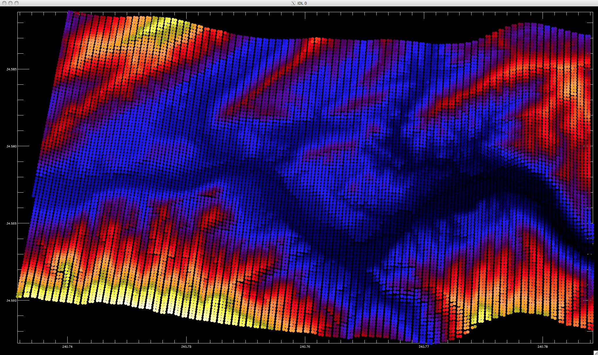
This image shows the LVIS scan and beam pattern. The unique LVIS scanning system generates this pattern that evenly and completely samples the surface below. There are approximately 100 beams across the 2 km wide swath. The colors represent the surface elevation (blue is low, yellow/white is high). The slight undulations at the top and bottom edges are a result of the aircraft roll. (Click image for full resolution)
Crane Glacier
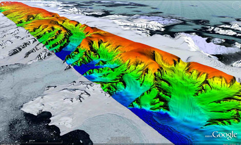
LVIS data over the Antarctic Peninsula draped onto the Google Earth background.
For more information and access to the Crane dataset click here.
LVIS Deployment Schedule
LVIS is planning multiple exciting missions in 2024 and beyond. To view our planned deployments, please browse the calendar above. If you have a proposal for add-on flight hours, please contact the LVIS team at gs-lvis@mail.nasa.gov.
