
Follow LVIS
External Links
- 61A: Geodesy and Geophysics Laboratory
- Operation IceBridge
- ABoVE
- NSIDC
- GEDI
- GRACE
- University of Maryland
Recent News
LVIS featured on #ScienceInSeconds
28 Jul 2021
Dr. Michelle Hofton was interviewed for NASA Associate Administrator Dr. Thomas Zurbuchen's Twitter update during the 2021 GEDI Calibration/Validation campaign!
Greenland data available at NSIDC
14 Jun 2018
LVIS Level 1B and 2 data products from Operation IceBridge Greenland 2017 are now available at NSIDC. Links are now available here!
ABoVE data available at NSIDC
9 May 2018
LVIS Level 1B and 2 data products from ABoVE 2017 are now available at NSIDC, and the IceBridge 2017 data products have been sent out. Take a look here!
ABoVE data sent to NSIDC
8 Mar 2018
LVIS data from ABoVE 2017 has been sent to NSIDC. As soon as the data is available, links will be posted here!
GEDI 2021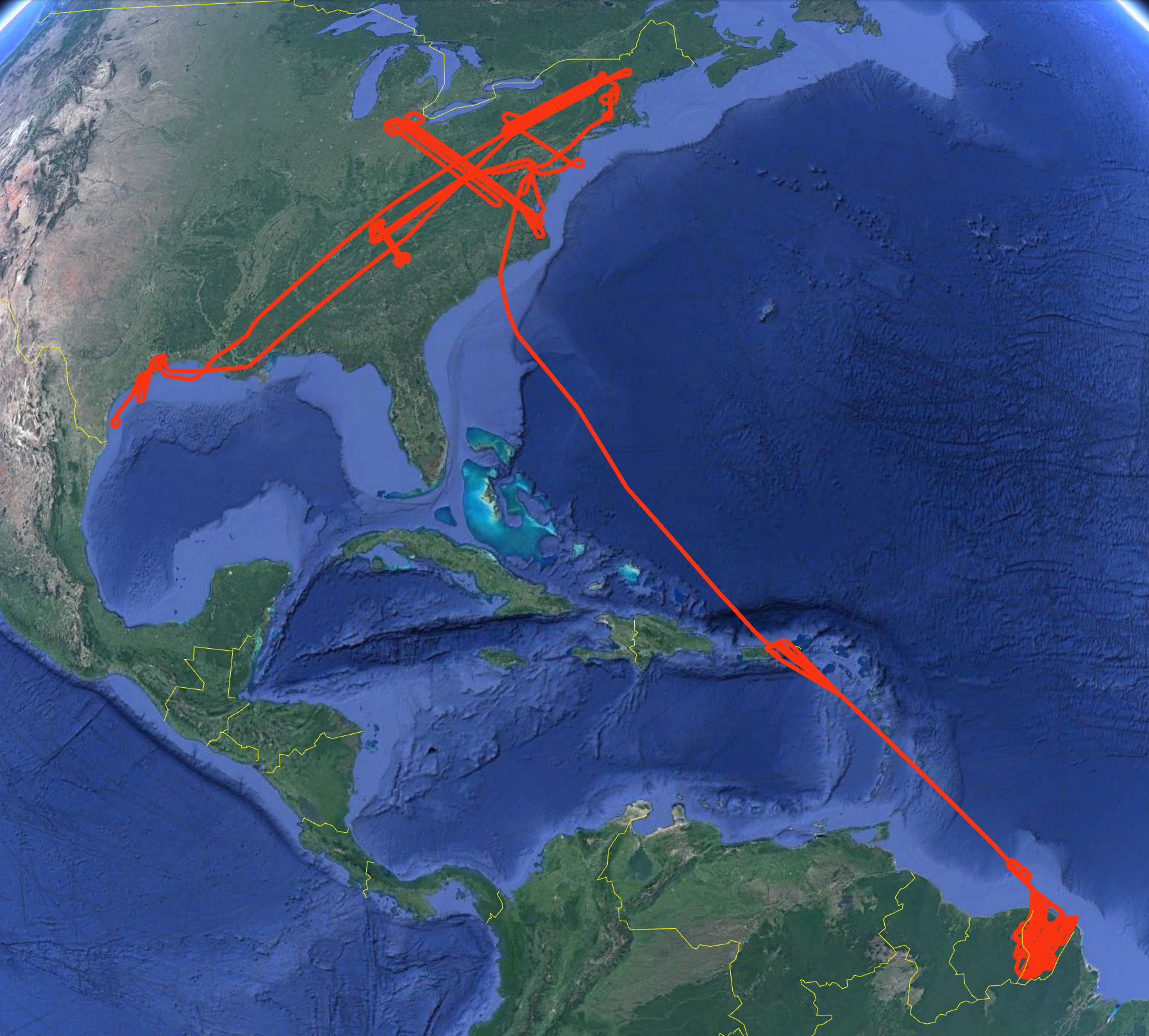
In July-August 2021, NASA's LVIS Facility flew over the eastern US and French Guiana collecting calibration and validation data for NASA's GEDI. Two LVIS lidars and two camera sensors were operated on the NASA G-V aircraft (collection parameters shown in mission information tables below). During the 3-week deployment eight flights were flown out of Baltimore, MD and San Juan, PR. Science targets in the US and French Guiana included sections of GEDI reference ground tracks, existing ground-based data collections, and previous LVIS data collection sites. Flight trajectories are available on this page. GEDI (Global Ecosystem Dynamics Investigation) is a space-based lidar sensor mounted on the ISS collecting surface topography and canopy height measurements between ~51 N and S since 2019. Use the python code posted here to view the data products from this mission. |
LVIS Mission Information
|
ResourcesAirports
| |||||||||||||||||||||||||||||||||||||||
Data Products
| LVIS Data Products | Format | Download Location |
| Flight Trajectories | KMZ | This page |
| Coverage Maps | KMZ | This page |
| LVIS L1A Camera Imagery | JPG* | NSIDC1, NASA EarthData |
| LVIS Classic L1B Geolocated Waveforms | HDF, LDS 2.0.3 | NSIDC1, NASA EarthData |
| LVIS Classic L2 Elevation and Height Products | ASCII TXT, LDS 2.0.3 | NSIDC1, NASA EarthData |
| LVIS Facility L1B Geolocated Waveforms | HDF, LDS 2.0.3 | NSIDC1, NASA EarthData |
| LVIS Facility L2 Elevation and Height Products | ASCII TXT, LDS 2.0.3 | NSIDC1, NASA EarthData |
1 At NSIDC, search for date ranges 01 Jul 2021 through 31 Aug 2021
| View | MJD | Date | Region / Remarks | GPS Flight Trajectory | Preliminary LVIS Coverage* (Key) | L2 Gridded KMZs† | Photo KMZs† | ||
|---|---|---|---|---|---|---|---|---|---|
| Classic | Facility | CAM1 | CAM2 | ||||||
| 59411 | 16 July 2021 | Sensor calibration flight, Gulf of Mexico | [kmz] | [kmz] | [kmz] | [kmz] | |||
| 59414 | 19 July 2021 | Houston to Baltimore, GEDI tracks in Louisiana, Mississippi, Alabama, Tennessee, Kentucky, West Virginia, Pennsylvania, and New Jersey | [kmz] | [kmz] |
[ZG] [RH95] |
[ZG] [RH95] |
[kmz] | [kmz] | |
| 59415 | 20 July 2021 | GEDI tracks in Ohio, West Virginia, and Virginia | [kmz] | [kmz] |
[ZG] [RH95] |
[ZG] [RH95] |
[kmz] | [kmz] | |
| 59418 | 23 July 2021 | GEDI tracks in French Guiana | [kmz] | [kmz] |
[ZG] [RH95] |
[ZG] [RH95] |
[kmz] | [kmz] | |
| 59422 | 27 July 2021 | GEDI tracks in French Guiana | [kmz] | [kmz] |
[ZG] [RH95] |
[ZG] [RH95] |
[kmz] | [kmz] | |
| 59424 | 29 July 2021 | GEDI tracks in French Guiana. Portions of some lines repeated at 23,000 ft altitude. |
[kmz] | [kmz] |
[ZG] [RH95] |
[ZG] [RH95] |
[kmz] | [kmz] | |
| 59426 | 31 July 2021 | GEDI tracks in French Guiana. Portions of some lines repeated at 23,000 ft altitude. |
[kmz] | [kmz] |
[ZG] [RH95] |
[ZG] [RH95] |
[kmz] | [kmz] | |
| 59427 | 01 August 2021 | San Juan to Baltimore | [kmz] | [kmz] |
[ZG] [RH95] |
[ZG] [RH95] |
[kmz] | [kmz] | |
| 59431 | 05 August 2021 | Mapping of Coweeta and Oak Ridge areas, TN. SERC line, MD. GEDI tracks in VA, WV. Portions of some lines repeated at 23,000 ft altitude. |
[kmz] | [kmz] |
[ZG] [RH95] |
[ZG] [RH95] |
[kmz] | [kmz] | |
| 59432 | 06 August 2021 | GEDI tracks in Pennsylvania, New York, Vermont, and New Hampshire. Harvard Forest mapping, MA. Line over Hubbard Brook LTER/Bartlett EF, NH | [kmz] | [kmz] |
[ZG] [RH95] |
[ZG] [RH95] |
[kmz] | [kmz] | |
| Jul - Aug 2021 | All Flights | [kmz] | |||||||
*Preliminary LVIS Coverage locations are generated shortly after a flight and based on quicklook product information and are intended for general guidance only.
Key: Red=0%, Pink=1-10%, Orange=10-20%, Yellow=20-50%, Green=50-100%
†Warning: Gridded and Photo KMZ files are large and may take some time to load in Google Earth
