
Follow LVIS
External Links
- 61A: Geodesy and Geophysics Laboratory
- Operation IceBridge
- ABoVE
- NSIDC
- GEDI
- GRACE
- University of Maryland
Recent News
LVIS featured on #ScienceInSeconds
28 Jul 2021
Dr. Michelle Hofton was interviewed for NASA Associate Administrator Dr. Thomas Zurbuchen's Twitter update during the 2021 GEDI Calibration/Validation campaign!
Greenland data available at NSIDC
14 Jun 2018
LVIS Level 1B and 2 data products from Operation IceBridge Greenland 2017 are now available at NSIDC. Links are now available here!
ABoVE data available at NSIDC
9 May 2018
LVIS Level 1B and 2 data products from ABoVE 2017 are now available at NSIDC, and the IceBridge 2017 data products have been sent out. Take a look here!
ABoVE data sent to NSIDC
8 Mar 2018
LVIS data from ABoVE 2017 has been sent to NSIDC. As soon as the data is available, links will be posted here!
Greenland April 2022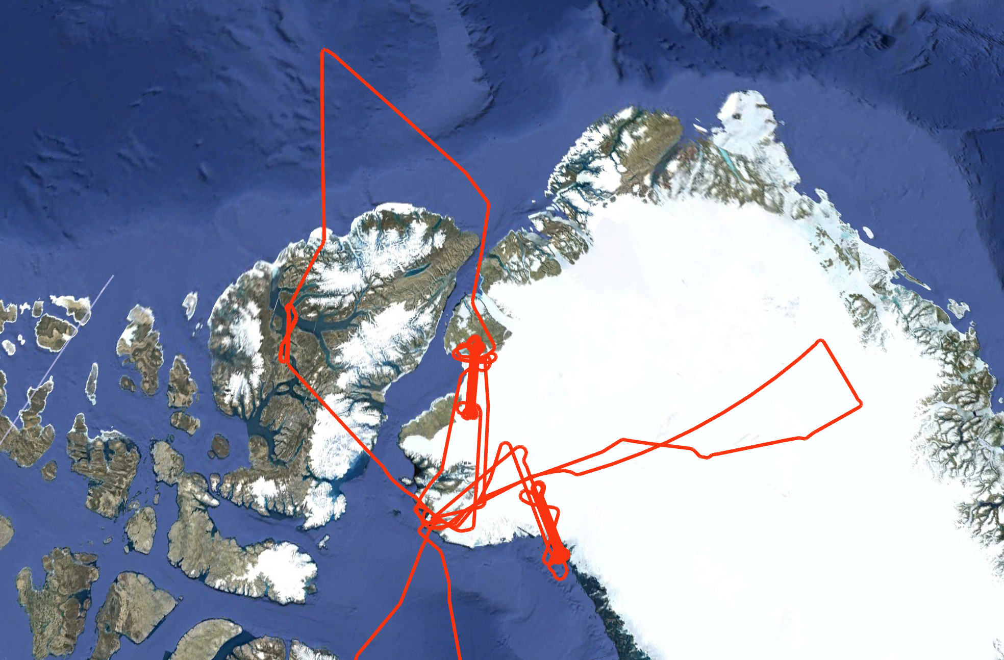
In April 2022, NASA's LVIS Facility was used to collect data over sections of the Greenland Ice Sheet and surrounding sea ice, supporting University of Kansas/CreSIS radar flights or future sensor design studies. The LVIS-F lidar sensor was used to collect surface elevation and structure information at low (1500’) or medium (23,000’) flight altitudes in the NASA P-3B, operating with 2 LVIS camera sensors and the KU/CReSIS radar sensor. Because of the different flight altitudes, collection parameters of the LVIS lidar and cameras varied (see mission information tables below for further details). Science targets included land and sea ice (from low flight altitudes), Humboldt Glacier and coastal and interior ice surfaces in western Greenland centered on recent ICESat-2 tracks (from medium flight altitudes). Flight trajectories are available on this page. Use the python code posted here to view the data products from this mission. |
LVIS Mission Information
|
ResourcesAirports
| |||||||||||||||||||||||||||||||||||||||
Data Products
| LVIS Data Products | Format | Download Location |
| Flight Trajectories | KMZ | This page |
| Coverage Maps | KMZ | This page |
| LVIS L1A Camera Imagery | JPG* | NSIDC1, NASA EarthData |
| LVIS Facility L1B Geolocated Waveforms | HDF, LDS 2.0.3 | NSIDC1, NASA EarthData |
| LVIS Facility L2 Elevation and Height Products | ASCII TXT, LDS 2.0.3 | NSIDC1, NASA EarthData |
1 At NSIDC, search for date ranges 01 Apr 2022 through 30 Apr 2022
| View | MJD | Date | Region / Remarks | GPS Flight Trajectory | Preliminary LVIS Coverage* (Key) | L2 Gridded KMZs† | Photo KMZs† |
|---|---|---|---|---|---|---|---|
| CAM020MP | |||||||
| 59681 | 12 April 2022 | Sensor calibration flight, Atlantic Ocean | [kmz] | [kmz] | [kmz] | ||
| 59687 | 18 April 2022 | Wallops Flight Facility to Thule Air Base | [kmz] | [kmz] | [kmz] | ||
| 59688 | 19 April 2022 | Greenland Ice Sheet (Low altitude) | [kmz] | [kmz] | [Zlow] | [kmz] | |
| 59690 | 21 April 2022 | Humboldt Glacier | [kmz] | [kmz] | [Zlow] | [kmz] | |
| 59691 | 22 April 2022 | Sea Ice, Ellesmere Island, Canada (Low altitude) | [kmz] | [kmz] | [Zlow] | [kmz] | |
| 59694 | 25 April 2022 | Interior and coastal ice, western Greenland | [kmz] | [kmz] | [Zlow] | [kmz] | |
| 59696 | 27 April 2022 | Transit from Thule Air Base to Dover Air Force Base | [kmz] | [kmz] | [kmz] | ||
| April 2022 | All Flights | [kmz] |
*Preliminary LVIS Coverage locations are generated shortly after a flight and based on quicklook product information and are intended for general guidance only.
Key: Red=0%, Pink=1-10%, Orange=10-20%, Yellow=20-50%, Green=50-100%
†Warning: Gridded and Photo KMZ files are large and may take some time to load in Google Earth
