
Follow LVIS
External Links
- 61A: Geodesy and Geophysics Laboratory
- Operation IceBridge
- ABoVE
- NSIDC
- GEDI
- GRACE
- University of Maryland
Recent News
LVIS featured on #ScienceInSeconds
28 Jul 2021
Dr. Michelle Hofton was interviewed for NASA Associate Administrator Dr. Thomas Zurbuchen's Twitter update during the 2021 GEDI Calibration/Validation campaign!
Greenland data available at NSIDC
14 Jun 2018
LVIS Level 1B and 2 data products from Operation IceBridge Greenland 2017 are now available at NSIDC. Links are now available here!
ABoVE data available at NSIDC
9 May 2018
LVIS Level 1B and 2 data products from ABoVE 2017 are now available at NSIDC, and the IceBridge 2017 data products have been sent out. Take a look here!
ABoVE data sent to NSIDC
8 Mar 2018
LVIS data from ABoVE 2017 has been sent to NSIDC. As soon as the data is available, links will be posted here!
United States 2018/2019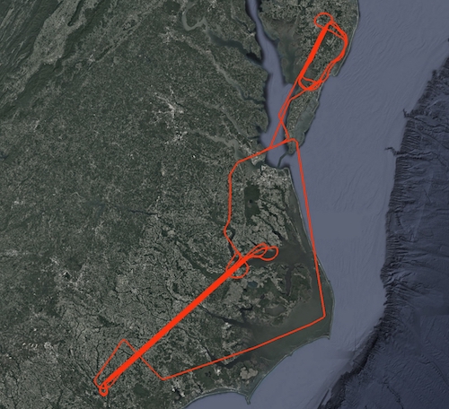
On 07 November 2018 and 31 January 2019, the NASA LVIS Facility was flown over sites in Maryland, Virginia, and North Carolina. Flights were based out of NASA's Langley Research Center in Hampton, VA. Flight trajectories and coverage maps are available on this page. Use the python code posted here to view the data products from this mission. |
LVIS Mission Information
|
ResourcesAirports
| ||||||||||||||||||||||||
Data Products
| LVIS Data Products | Format | Download Location |
| Flight Trajectories | KMZ | This page |
| Coverage Maps | KMZ | This page |
| LVIS L1A Camera Imagery | JPG* | NSIDC1, NASA EarthData |
| LVIS Facility L1B Geolocated Waveforms | HDF, LDS 2.0.3 | NSIDC1, NASA EarthData |
| LVIS Facility L2 Elevation and Height Products | ASCII TXT, LDS 2.0.3 | NSIDC1, NASA EarthData |
1 At NSIDC, search for date ranges 01 Nov 2018 through 31 Jan 2019
*Image position and attitude embedded in exif data.
| View | MJD | Date | Region / Remarks | GPS Flight Trajectory | L2 Gridded KMZs† | Photo KMZs† |
|---|---|---|---|---|---|---|
| 58429 | 07 Nov 2018 | Delmarva Peninsula in Maryland and Virginia | [kmz] | [ZG] [RH95] |
[kmz] | |
| 58514 | 31 Jan 2019 | Pamlico Sound and eastern North Carolina | [kmz] | [ZG] [RH95] |
[kmz] |
†Warning: Gridded and Photo KMZ files are large and may take some time to load in Google Earth
