
Follow LVIS
External Links
- 61A: Geodesy and Geophysics Laboratory
- Operation IceBridge
- ABoVE
- NSIDC
- GEDI
- GRACE
- University of Maryland
Recent News
LVIS featured on #ScienceInSeconds
28 Jul 2021
Dr. Michelle Hofton was interviewed for NASA Associate Administrator Dr. Thomas Zurbuchen's Twitter update during the 2021 GEDI Calibration/Validation campaign!
Greenland data available at NSIDC
14 Jun 2018
LVIS Level 1B and 2 data products from Operation IceBridge Greenland 2017 are now available at NSIDC. Links are now available here!
ABoVE data available at NSIDC
9 May 2018
LVIS Level 1B and 2 data products from ABoVE 2017 are now available at NSIDC, and the IceBridge 2017 data products have been sent out. Take a look here!
ABoVE data sent to NSIDC
8 Mar 2018
LVIS data from ABoVE 2017 has been sent to NSIDC. As soon as the data is available, links will be posted here!
ABoVE 2019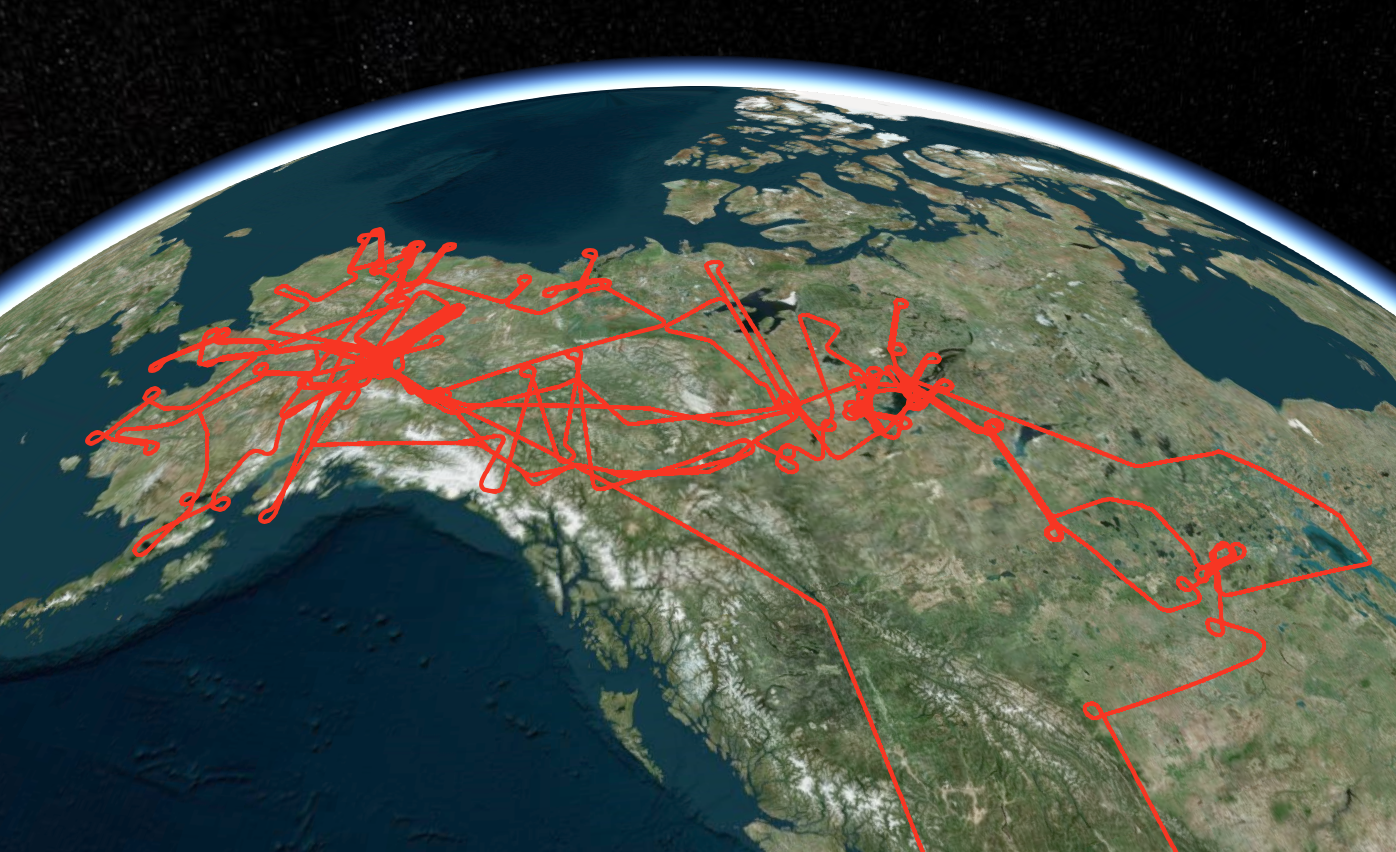
In July-August 2019, the NASA LVIS Facility and LVIS Classic were deployed to sites in northern Canada and Alaska as part of NASA's Arctic-Boreal Vulnerability Experiment (ABoVE) 2019 airborne campaign. During the 4 week deployment of LVIS, a total of 15 flights were flown over candidate science targets based out of multiple airports in Canada and Alaska. Flight trajectories and preliminary coverage maps are available on this page. Use the python code posted here to view the data products from this mission. |
LVIS Mission Information
|
ResourcesAirports
| |||||||||||||||||||||||||||||||||||||||
Data Products
| LVIS Data Products | Format | Download Location |
| Flight Trajectories | KMZ | This page |
| Coverage Maps | KMZ | This page |
| LVIS L1A Camera Imagery | JPG* | NSIDC1, NASA EarthData |
| LVIS Classic L1B Geolocated Waveforms | HDF, LDS 2.0.3 | NSIDC1, NASA EarthData |
| LVIS Classic L2 Elevation and Height Products | ASCII TXT, LDS 2.0.3 | NSIDC1, NASA EarthData |
| LVIS Facility L1B Geolocated Waveforms | HDF, LDS 2.0.3 | NSIDC1, NASA EarthData |
| LVIS Facility L2 Elevation and Height Products | ASCII TXT, LDS 2.0.3 | NSIDC1, NASA EarthData |
1 At NSIDC, search for date ranges 01 Jul 2019 through 31 Aug 2019
| View | MJD | Date | Region / Remarks | GPS Flight Trajectory | Preliminary LVIS Coverage* (Key) | L2 Gridded KMZs† | Photo KMZs† | ||
|---|---|---|---|---|---|---|---|---|---|
| Classic | Facility | CAM1 | CAM2 | ||||||
| 58676 | 12 Jul 2019 | Houston to Yellowknife, GEDI Reference Ground Tracks | [kmz] | [kmz] |
[ZG 1/2] [ZG 2/2] [RH95 1/2] [RH95 2/2] |
[kmz] | [kmz] | ||
| 58677 | 13 Jul 2019 | BERMS, PAD, 2010 Lidar | [kmz] | [kmz] |
[ZG 1/2] [ZG 2/2] [RH95 1/2] [RH95 2/2] |
[kmz] | [kmz] | ||
| 58679 | 15 Jul 2019 | McKenzie River, Normal Wells, Scotty Creek, ICESat-2, Great Slave Lake | [kmz] | [kmz] |
[ZG 1/2] [ZG 2/2] [RH95 1/2] [RH95 2/2] |
[kmz] | [kmz] | ||
| 58680 | 16 Jul 2019 | Daring Lake, PAD, Great Slave Lake, 2010 Lidar | [kmz] | [kmz] |
[ZG 1/2] [ZG 2/2] [RH95 1/2] [RH95 2/2] |
[kmz] | [kmz] | ||
| 58682 | 18 Jul 2019 | Yellowknife to Fairbanks, Kakisa Lake, Scotty Crek, 2010 Lidar, Delta Junction, ICESat-2 | [kmz] | [kmz] |
[ZG 1/2] [ZG 2/2] [RH95 1/2] [RH95 2/2] |
[kmz] | [kmz] | ||
| 58686 | 22 Jul 2019 | Healy, Bonanza Creek, Yukon Flats, Delta Junction | [kmz] | [kmz] |
[ZG 1/2] [ZG 2/2] [RH95 1/2] [RH95 2/2] |
[kmz] | [kmz] | ||
| 58687 | 23 Jul 2019 | Southwest Alaska, Central Interior | [kmz] | [kmz] |
[ZG 1/2] [ZG 2/2] [RH95 1/2] [RH95 2/2] |
[kmz] | [kmz] | ||
| 58689 | 25 Jul 2019 | Northern Alaska, Prudhoe Bay, Old Crow, Mackenzie River, Inuvik, Delta Junction, Shovel Creek | [kmz] | [kmz] |
[ZG 1/2] [ZG 2/2] [RH95 1/2] [RH95 2/2] |
[kmz] | [kmz] | ||
| 58691 | 27 Jul 2019 | Seward Peninsula, Shovel Creek, Delta Junction | [kmz] | [kmz] |
[ZG 1/2] [ZG 2/2] [RH95 1/2] [RH95 2/2] |
[kmz] | [kmz] | ||
| 58692 | 28 Jul 2019 | Seward Peninsula, YK Delta, Shovel Creek | [kmz] | [kmz] |
[ZG 1/2] [ZG 2/2] [RH95 1/2] [RH95 2/2] |
[kmz] | [kmz] | ||
| 58693 | 29 Jul 2019 | Western Alaska, Utqiagvik, Nuisqut, ICESat-2, Shovel Creek | [kmz] | [kmz] |
[ZG 1/2] [ZG 2/2] [RH95 1/2] [RH95 2/2] |
[kmz] | [kmz] | ||
| 58695 | 31 Jul 2019 | Yukon Territory, Kluane Lake, Whitehorse, Fort Watson, ICESat-2 | [kmz] | [kmz] |
[ZG 1/2] [ZG 2/2] [RH95 1/2] [RH95 2/2] |
[kmz] | [kmz] | ||
| 58696 | 01 Aug 2019 | ICESat-2, 2010 Lidar, Shovel Creek | [kmz] | [kmz] |
[ZG 1/2] [ZG 2/2] [RH95 1/2] [RH95 2/2] |
[kmz] | [kmz] | ||
| 58702 | 06 Aug 2019 | Fairbanks to Salt Lake City, ICESat-2, Wind River, GEDI Reference Ground Tracks | [kmz] | [kmz] |
[ZG 1/2] [ZG 2/2] [RH95 1/2] [RH95 2/2] |
[kmz] | [kmz] | ||
| 58702 | 07 Aug 2019 | Salt Lake City to Houston, GEDI Reference Ground Tracks | [kmz] | [kmz] |
[ZG 1/2] [ZG 2/2] [RH95 1/2] [RH95 2/2] |
[kmz] | [kmz] | ||
| Jul - Aug 2019 | All Flights | [kmz] | |||||||
*Preliminary LVIS Coverage locations are generated shortly after a flight and based on quicklook product information and are intended for general guidance only.
Key: Red=0%, Pink=1-10%, Orange=10-20%, Yellow=20-50%, Green=50-100%
†Warning: Gridded and Photo KMZ files files are large and may take some time to load in Google Earth
