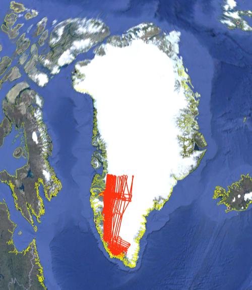
IceBridge 2011, Greenland

In Spring 2011, the NASA LVIS was deployed to Greenland for NASA's Operation IceBridge Spring Campaign based from Kangerlussuaq. Multiple flights were flown over the icesheet. Data are available in Level1B and Level2 formats. The Level1b data files contain the geolocated laser waveform data for each laser footprint. The Level2 data files contain elevations of reflecting surfaces, derived from the Level1b data. Level 2 files are much smaller and more manageable. For those users not familiar with waveform lidar data, we recommend that you start with the Level2 files before moving to the Level1b files (e.g., for context or to apply different algorithms). The Level1B data are in HDF5 and the Level2 data are in ascii.


LVIS Mission Information

LVIS Lidar
Instrument Version: LVIS
Flight Platform: LARC King Air B-200
Nominal Flight Altitude: 28,000'
Nominal LVIS Swath Width: 1.8km
Nominal LVIS Footprint Diameter: 20m

Resources

Data Products

LVIS Data Products Format Download Location
Flight TrajectoriesKMZThis page
LVIS L1B Geolocated WaveformsHDF, LDS 1.04NSIDC1, NASA EarthData
LVIS L2 Elevation and Height ProductsASCII TXT, LDS 1.04NSIDC1, NASA EarthData

1 At NSIDC, search for date ranges 01 Apr 2011 through 31 May 2011


Display MJD Date Region / Remarks Platform Flight Trajectory
55666 15 Apr 2011 2 Flights - Both in Box 2
ICESat tracks 1290, 55, 174, 1297
LARC King Air B-200 [JPEG] [PDF] [kmz] [shp]
55667 16 Apr 2011 2 Flights - Both in Box 2 LARC King Air B-200 [JPEG] [PDF] [kmz] [shp]
55669 18 Apr 2011 2 Flights - Both in Box 2 LARC King Air B-200 [JPEG] [PDF] [kmz] [shp]
55670 19 Apr 2011 1 Flight in Box 4
2500 m contour
ICESat tracks 55, 181
LARC King Air B-200 [JPEG] [PDF] [kmz] [shp]
55671 20 Apr 2011 1 Flight in Box 3
ICESat tracks 70, 308
LARC King Air B-200 [JPEG] [PDF] [kmz] [shp]
55672 21 Apr 2011 1 Flight in Box 5
ICESat track 323
LARC King Air B-200 [JPEG] [PDF] [kmz] [shp]
55673 22 Apr 2011 1 Flight in Box 5
EGIG Line
ICESat track 419
LARC King Air B-200 [JPEG] [PDF] [kmz] [shp]
55676 25 Apr 2011 1 Flight in Box 5
ICESat track 174
LARC King Air B-200 [JPEG] [PDF] [kmz] [shp]
55683 02 May 2011 1 Flight in Box 3
Isunguata Glacier
ICESat track 55
LARC King Air B-200 [JPEG] [PDF] [kmz] [shp]
55684 03 May 2011 1 Flight in Box 5
2000 m contour
ICESat tracks 32, 308, 1290
LARC King Air B-200 [JPEG] [PDF] [kmz] [shp]
55686 05 May 2011 2 Flights in Boxes 3 & 4
LARC King Air B-200 [JPEG] [PDF] [kmz] [shp]
55687 06 May 2011 2 Flights in Boxes 4 & 5
LARC King Air B-200 [JPEG] [PDF] [kmz] [shp]
55688 07 May 2011 1 Flight in Box 3 LARC King Air B-200 [JPEG] [PDF] [kmz] [shp]
Mar - Apr 2011 All Greenland 2011 Flights LARC King Air B-200 [kmz] [shp]