
Follow LVIS
External Links
- 61A: Geodesy and Geophysics Laboratory
- Operation IceBridge
- ABoVE
- NSIDC
- GEDI
- GRACE
- University of Maryland
Recent News
LVIS featured on #ScienceInSeconds
28 Jul 2021
Dr. Michelle Hofton was interviewed for NASA Associate Administrator Dr. Thomas Zurbuchen's Twitter update during the 2021 GEDI Calibration/Validation campaign!
Greenland data available at NSIDC
14 Jun 2018
LVIS Level 1B and 2 data products from Operation IceBridge Greenland 2017 are now available at NSIDC. Links are now available here!
ABoVE data available at NSIDC
9 May 2018
LVIS Level 1B and 2 data products from ABoVE 2017 are now available at NSIDC, and the IceBridge 2017 data products have been sent out. Take a look here!
ABoVE data sent to NSIDC
8 Mar 2018
LVIS data from ABoVE 2017 has been sent to NSIDC. As soon as the data is available, links will be posted here!
Instrument Details
A laser altimeter is an instrument that measures range from the instrument to a target object or surface. The device sends a laser beam towards the target, and measures the time it takes for the signal to return from striking the surface. Knowing the precise time the laser pulse was emitted, and the time it took for the reflection to return yields the range to the target.
There are several common methods for taking this measurement. LVIS employs a signal digitizer, disciplined with a very precise oscillator, to measure both the transmitted and reflected laser pulse energies versus time. These digitized and captured photon histories are known as waveforms. For the outgoing pulse, it represents the profile of the individual laser shot, and for the return pulse it records the interaction of that transmitted pulse with the target surface.
Processing of these waveforms yields many products, but the primary is range from the instrument to the Earth's surface and the distribution of surfaces above the terrain. Generally these surfaces are trees, branches and other forms of vegetation, buildings and power lines, and ice crevasses surfaces. LVIS is an altimeter tailored for collecting large swaths of data from a high altitude aircraft platform. The laser beam and telescope field of view scan a raster pattern along the surface as the plane travels over the target area.
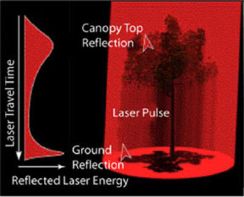
Laser Pulse. The following plot shows a waveform for a laser pulse striking a single tree canopy and the Earth's surface. Our beam diameter scales with the range to the target (i.e. Gets larger the farther we are away from the target), and our typical collection size is 5 to 25 meter spots.
How are 3-D maps made?
To determine the latitude, longitude, and elevation of a given spot on the surface, it is necessary to know not only the distance to the surface, but the location of the instrument's platform (i.e., an airplane), as well as the direction the laser altimeter was looking. GPS, or satellite-based Global Positioning Systems, are used for this purpose. GPS satellite data is recorded at ground tie locations and on the airborne platform to precisely reference aircraft. An IMU is attached directly to the instrument, and gives the pointing information required for coordinate determination.
To create a 3-D map or image of the surface, post flight processing software combines all the data from the GPS, IMU and LVIS instruments. The resulting 'point cloud' of laser return data can then be filtered and gridded to generate digital elevation model (DEM) of the topography or any of the derived data products.
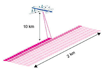
The LVIS transmit beam is scanned perpendicular to direction the aircraft is pointed, as show in the diagram. The laser scan is adjusted by real time software to remove platform angle changes as well as forward motion effects. Data on the surface below these swaths are collected, and a DEM and map can be generated from them. LVIS has a scan angle of about 12 degrees, and can cover 2 km swaths of surface from an altitude of 10 km.
