| Item |
Byte Size |
Format |
Units |
Item Description |
| LFID |
4 |
unsigned longword integer |
|
LVIS file identification |
| shotnumber |
4 |
unsigned longword integer |
|
laser shot assigned during collection |
| time |
8 |
double precision floating point |
seconds |
UTC decimal seconds of the day |
| glon |
8 |
double precision floating point |
degrees |
longitude of the lowest detected mode within the waveform (degrees east) |
| glat |
8 |
double precision floating point |
degrees |
latitude of the lowest detected mode within the waveform (degrees north) |
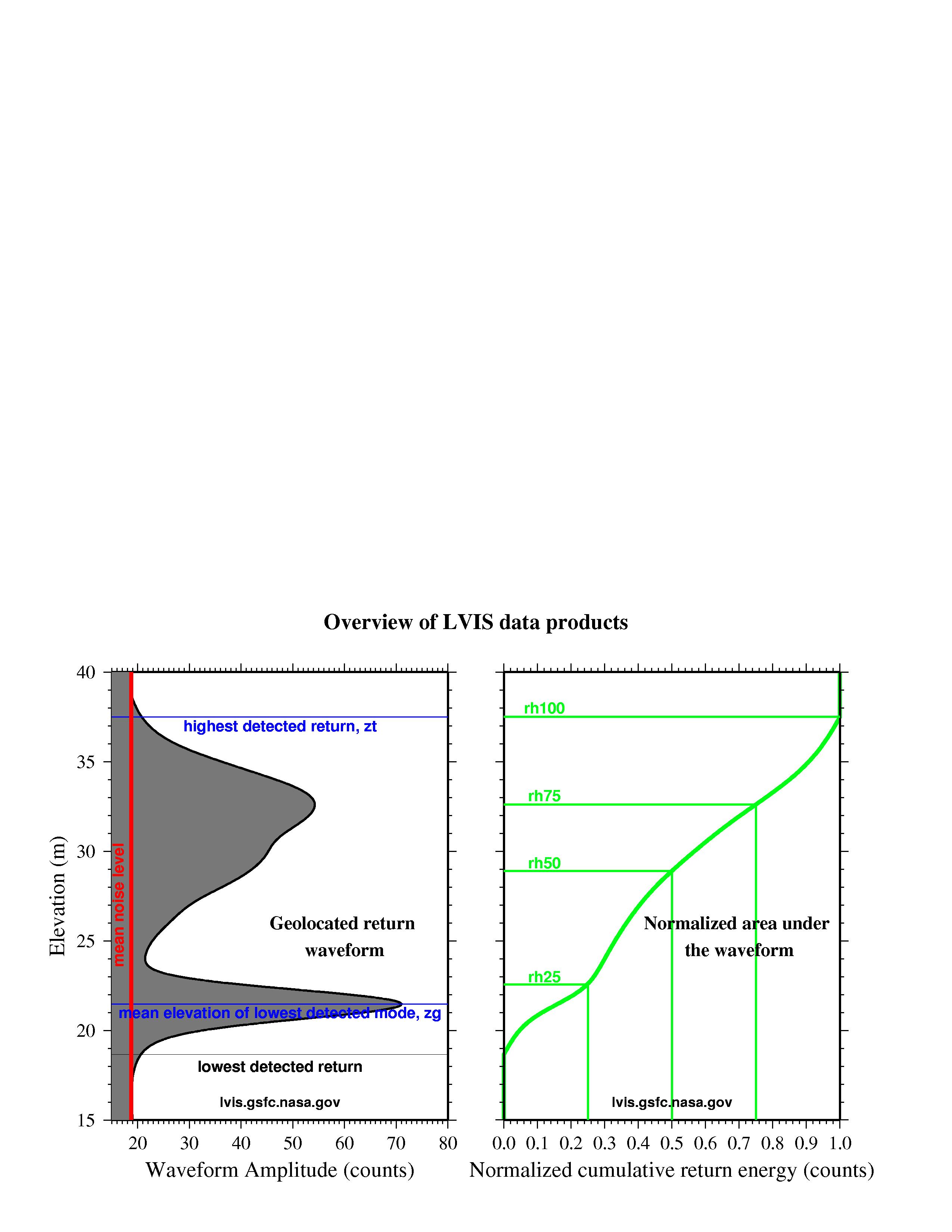
| zg |
4 |
single precision floating point |
meters |
mean elevation of the lowest detected mode within the waveform
(see here) |
| RH25 |
4 |
single precision floating point |
meters |
height (relative to zg) at which 25% of the waveform energy occurs
(see here) |
| RH50 |
4 |
single precision floating point |
meters |
height (relative to zg) at which 50% of the waveform energy occurs
(see here) |
| RH75 |
4 |
single precision floating point |
meters |
height (relative to zg) at which 75% of the waveform energy occurs
(see here) |
| RH100 |
4 |
single precision floating point |
meters |
height (relative to zg) at which 100% of the waveform energy occurs
(see here) |
| TOTAL |
52 |
|
|
bytes per record |
| Item |
Byte Size |
Format |
Units |
Item Description |
| LFID |
4 |
unsigned longword integer |
|
LVIS file identification |
| shotnumber |
4 |
unsigned longword integer |
|
laser shot assigned during collection |
| time |
8 |
double precision floating point |
seconds |
UTC decimal seconds of the day |
| lon0 |
8 |
double precision floating point |
degrees |
longitude of the highest sample of the waveform (degrees east) |
| lat0 |
8 |
double precision floating point |
degrees |
latitude of the highest sample of the waveform (degrees north) |
| z0 |
4 |
single precision floating point |
meters |
elevation of the highest sample of the waveform |
| lon431 |
8 |
double precision floating point |
degrees |
longitude of the lowest sample of the waveform (degrees east) |
| lat431 |
8 |
double precision floating point |
degrees |
latitude of the lowest sample of the waveform (degrees north) |
| z431 |
4 |
single precision floating point |
meters |
elevation of the lowest sample of the waveform |
| sigmean |
4 |
single precision floating point |
counts |
signal mean noise level, calculated in-flight |
| wave |
432 |
byte |
counts |
return waveform, recorded in-flight |
| TOTAL |
492 |
|
|
bytes per record |

